 | Understanding How GPS, Remote Sensing and IDI Work |
7.5 |
7.6 |
7.7 |
7.8 |
7.9 |
7.10 |
7.11 |
7.1 |
7.2 |
7.3 |
7.4 |
|
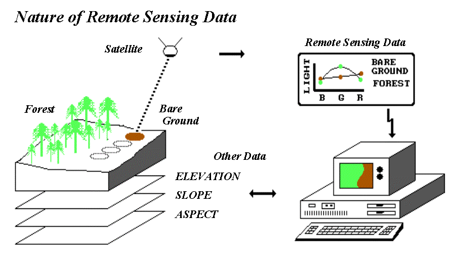
7.9 - When these spots (termed pixels for "picture elements") are displayed on a computer, they form an image similar to an aerial photograph. In fact, a photograph can be "scanned" to generate a digital imagelike pulling the satellite out of the sky and passing it over the photo instead of the actual terrain. The important point is that behind any digital image there are millions of numbers recording the various types of light reflected from each instantaneous spot.
Three factors govern the quality and appropriateness of remote sensing data: 1) spatial, 2) spectral and 3) temporal resolutions.
Spatial resolution identifies the smallest thing (spatial unit) contained in the data. In a photograph, it is a glob of developed crystals embedded in the emulsion; in a digital image its the size of the pixel. Up to a point, smaller is better. If there is too much spatial detail, you "cant see the forest for the trees," nor store the burgeoning file.
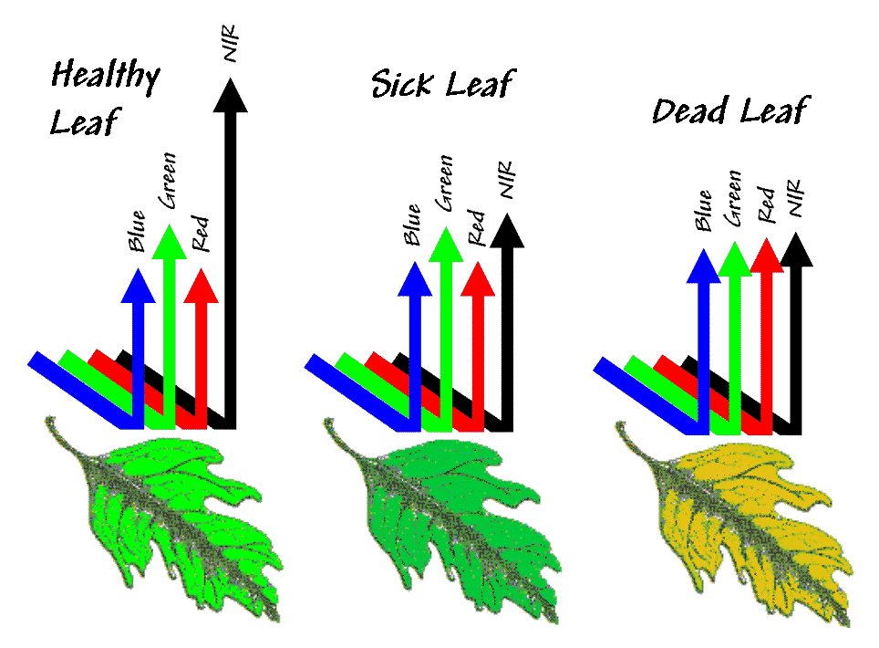
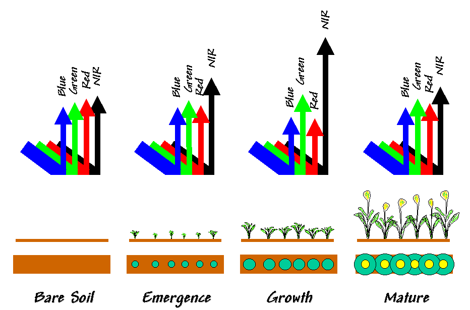
Spectral resolution refers to the number and width of the wavelength bands (colors) contained in the data. Again, more is better, up to a point. The human eye and normal film "see" just three broad bands of lightblue, green and red. Optical scanners can record many more narrowly defined bands that can be "tuned" for specific wavelengths to enhance features of interest. The ability to extend the bands beyond our vision (particularly to near infrared energy) and analyze just the important ones allows us to gain a lot more information from the data than simply viewing an image.
The rub is that there is a tradeoff between spatial and spectral resolutionspushing both of them to the maximum results in too little energy for a sensors detector. Early satellite systems required a lot of energy to activate their detectors; therefore, they only had four broad bands and a footprint of about an acre. Modern detectors can record many more narrow bands and commonly have a footprint of only a few meters. At these resolutions (spectral and spatial), even satellite data becomes appropriate for some aspects of site-specific management.
Temporal resolution refers to the time step between images. A series of images collected each week over a field provides far more information than a single image taken at just one point in the crops growth. You guessed it; more is better, up to a point. But this time the point isnt driven by optical physics but your wallet. By its very nature, site-specific management implies small areas, while most remote sensing systems (particularly satellites) are designed to service large areas. Pricing and distribution channels for digital data in smaller bites (and bytes) and turn-around times needed by farmers are just now coming on line.
While the full potential of remote sensing might be just around the corner, an aerial photo backdrop is an essential element of any precision farming system. Theres a growing number of ways you can acquire such an image. If youre lucky you can download a "rectified" image from the Internet or pick up one from a governmental agency in your locale. Some farmers have struck a deal with the local flight instructor to snap a few frames over their fields a couple of times a month. The 35 mm slides are scanned for a few dollars at growing numbers of photo shops. The digital images can be aligned in most desktop mapping systems using the GPS coordinates of a set of control points visible in the image.
Once the photo backdrop is in place, it immediately adds reality to the abstract lines and colors of a map. Important features and patterns can be encoded by tracing them directly on the screen (termed heads-up digitizing). This ability is an important component to drawing management zones discussed in "topic 2, Zones and Surfaces." Linking a differentially-corrected GPS unit to a portable computer allows you to "walk or drive" on a backdrop-photo (really cool!), encoding a map as you go (termed feet-down digitizing). Before you start drawing on maps, you need to realize that the patterns you see are the result of complex biological and physical interactions; you might "see" something, but be sure you know what it is before you canonize it as a map.
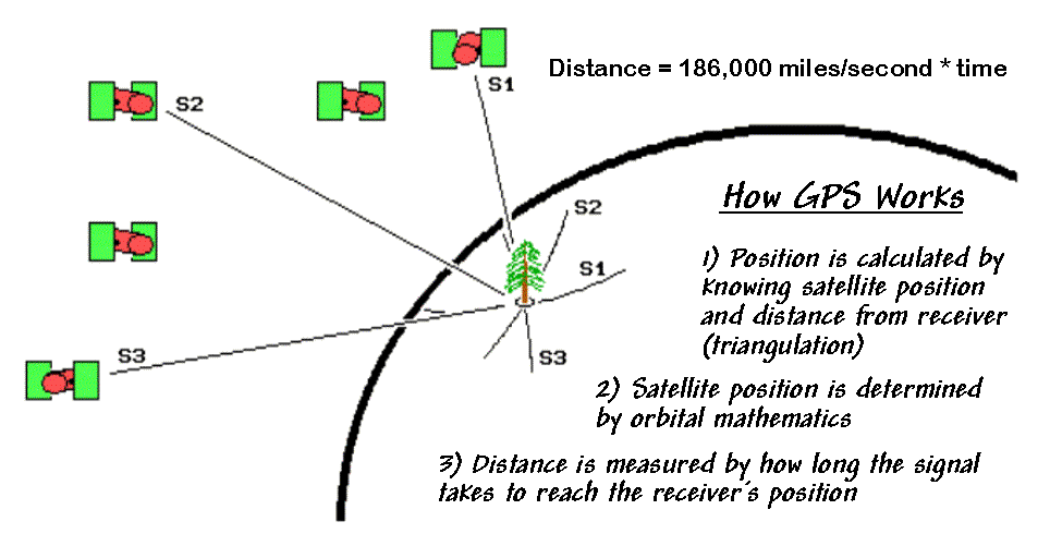
GPS and Remote Sensing - 2 different types of satellites
Gis and GPS