 | Map Measurement and Transformation |
|
|
|
|
|
|
|
|
|
|
|
|
|
|
|
|
|
|
|
|
|
|
|
|
|
|
|
|
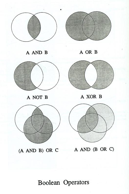
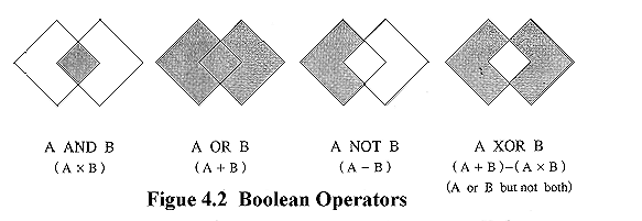
Boolean Operators venn diadramms |
http://www.agri.ubu.ac.th/sura/GIS_METEO/Index.htm |

Map of Thailand
Thai_Map.gif
Major area of GIS applications
Applications.gif
GIS information structure
Info_Structure.gif
GIS for decision support
DSS_GIS.gif
Land suit study for rice production
Exc_LandSuit_Model.gif
Major data sources for GIS
Req_Data.gif
Key success in GIS works
Key_Success_GIS.gif
Organization of human resources in GIS
Human_Resources.gif
Ideal GIS
Ideal_GIS.gif
Problems from digitizing
Digit_Problems.gif
Digitizing equipment
Digitize.gif
Major type of scanners
Scanner.gif
Advance data acquisition methods
Adv_Dat_Acqui.gif
Concept of coverage rebuilding
Map_Rebuild.gif
Major operation of feature extraction
Feature Extraction.gif
Examples of spatial analysis
Spatial analysis models.gif
Concept of database model
Database_models.gif
Map layers
Layers.gif
Boolean operator
boolean.gif
Overlay example for data interpretation
DataInte.jpg
Overlay of vector data
Vector_overley.gif
Graphic representation on map
Graphic representation.gif
Relationship between scale, accuracy and resolution
Scale_Reso.gif
Two week course for elementary GIS
GIS_Course.gif
Remote sensing
Hurricane from satellite
HURRIC30.jpg
Kay Typhoon hit Thailand
Key_Taiphon.gif
Hurricane Andrew
ANDYRE10.jpg
Satellite map show cloud cover Africa
Affica_map.gif
Current earth observation satellites
Satelites.gif
Mensell color system
Color System.gif
Typical color composition
color_Composite.gif
Typical Image classification methods
Image_Classification.gif
Major procedure in digital image processing
Image_Processing.gif
Concept of Maximum likelihood classifier
Maximum Like.gif
Deferent type of DEMs
DEM_model.gif
Example of relief maps
http://www.agri.ubu.ac.th/sura/GIS_METEO/Index.htm
next pictures
Reclassification and some extra pictures
GIS METEO
Map Measurement and Transformation