 | Analysis of Geographic Data |
Spatial Analysis - An Application |
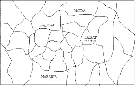
A Road Network |
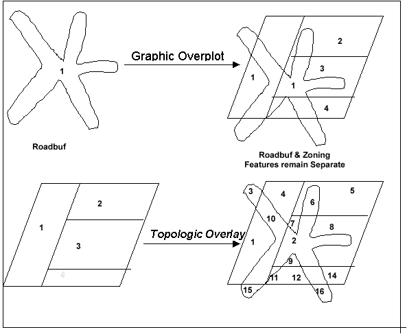
Polygon-on-Polygon Overlay |
Difference between a Topologic Overlay and a Graphic Over plot |
Raster Overlay |
using buffers |
Spatial Analysis - a Process |
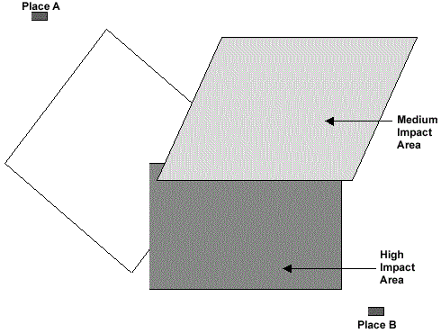
Where should we build a road from a point A to point B?
How do we minimise the impacts of building this road?
Relationship of Modelling to Analysis
Decision Models search through potential alternatives to arrive at a recommendation.
Decision support models process raw data into forms that are directly relevant to decision making.
Data characterisation models are used to develop a better understanding of a system to help characterise a problem or potential solutions.
Difficulties of Geographic Analysis
Plenty of data.
Spatial relationships are important but difficult to measure.
Inherent uncertainty due to scale.
any data sources.
Difficult to make data sources compatible.
Difficult mathematics.
Quantity vs. Quality Questions.
Multiple objectives.
GIS can address some (but not all) of these difficulties.
Network Analysis
Network models are based on interconnecting logical components, of which the most important are:
"Nodes" define start, end, and intersections
"Chains" are line features joining nodes
"Links" join together points making up a chain.
This network can be analyzed using GIS.A simple and most apparent network analysis applications are:
Street network analysis,
Traffic flow modelling,
Telephone cable networking,
Pipelines etc.
The other obvious applications would be service centre locations based on travel distance.
Basic forms of network analysis simply extract information from a network. More complex analysis, process information in the network model to derive new information. One example of this is the classic shortest-path between two points. The vector mode is more suited to network analysis than the raster model.
Tabular Statistical Analysis
If in the above road network we have categorised the streets then in such a case the statistical analysis answers questions like
What unique categories do I have for streets?
How many features do I have for each unique category?
Summarize by using any attribute?
Database Query
The selective display and retrieval of information from a database are among the fundamental requirements of GIS. The ability to selectively retrieve information from GIS is an important facility. Database query simply asks to see already stored information. Basically there are two types of query most general GIS allow: viz.,
Query by attribute,
Query by geometry.
Map features can be retrieved on the basis of attributes, For example, show all the urban areas having the population density greater than 1,000 per square kilometer, Many GIS include a sophisticated function of RDBMS known as Standard Query Language (SQL), to search a GIS database. The attribute database, in general, is stored in a table (relational database mode.) with a unique code linked to the geometric data. This database can be searched with specific characteristics. However, more complex queries can be made with the help of SQL.
GIS can carry out a number of geometric queries. The simplest application, for example, is to show the attributes of displayed objects by identifying them with a graphical cursor. There are five forms of primitive geometric query: viz.,
Query by point,
Query by rectangle,
Query by circle,
Query by line,
Query by polygon,
A more complex query still is one that uses both geometric and attributes search criteria together. Many GIS force the separation of the two different types of query. However, some GIS, using databases to store both geometric and attribute data, allow true hybrid spatial queries.
Overlay Operations
The hallmark of GIS is overlay operations. Using these operations, new spatial elements are created by the overlaying of maps.
There are basically two different types of overlay operations depending upon data structures:
Raster overlay It is a relatively straightforward operation and often many data sets can be combined and displayed at once.
Vector overlay The vector overlay, however is far more difficult and complex and involves more processing.
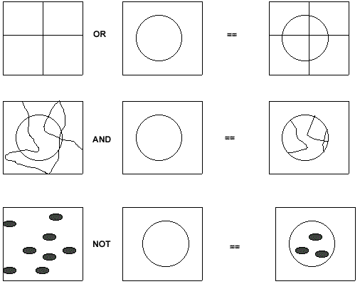
Logical Operators
The concept of map logic can be applied during overlay. The logical operators are Boolean functions. There are basically four types of Boolean Operators: viz., OR, AND, NOT, and XOR.
With the use of logical, or Boolean, operators spatial elements / or attributes are selected that fulfill certain condition, depending on two or more spatial elements or attributes.
Vector Overlay
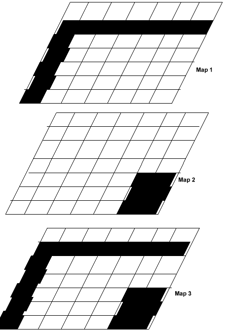
During vector overlay, map features and the associated attributes are integrated to produce new composite maps. Logical rules can be applied to how the maps are combined. Vector overlay can be performed on different types of map features: viz.,
Polygon-on-polygon overlay
Line-in-polygon overlay
Point-on-polygon overlay
During the process of overlay, the attribute data associated with each feature type id merged. The resulting table will contain both the attribute data. The process of overlay will depend upon the modelling approach the user needs. One might need to carry out a series of overlay procedures to arrive at the conclusion, which depends upon the criterion.
Raster Overlay
In raster overlay, the pixel or grid cell values in each map are combined using arithmetic and Boolean operators to produce a new value in the composite map. The maps can be treated as arithmetical variables and perform complex algebraic functions. The method is often described as map algebra. The raster GIS provides the ability to perform map layers mathematically. This is particularly important for the modelling in which various maps are combined using various mathematical functions. Conditional operators are the basic mathematical functions that are supported in GIS.
Conditional Operators
Conditional operators were already used in the examples given above. The all evaluate whether a certain condition has been met.
= eq ''equal'' operator
<> ne ''non-equal'' operator
< lt ''less than'' operator
<= le ''less than or equal'' operator
> gt ''greater than'' operator
>= ge ''greater than or equal'' operator
Many systems now can handle both vector and raster data. The vector maps can be easily draped on to the raster maps.
G. RELATIONSHIPS IN RASTER SYSTEMS
- in general, it is easier to work with relationships in vector systems
- the concept of object is not as natural for raster systems, which model the world as composed of pixels
- however, relationships can be handled in raster systems with simple techniques:
overhead - Relationships in raster systems
- e.g. a map of county boundaries
- in one layer each pixel has a county code attribute which is an ID pointing to an entry in a county attribute table
- in a second layer each well location is coded by giving the appropriate pixel an ID pointing to a well attribute table
- the "is contained in" relationship can be computed by an overlay operation and stored as an additional column in the well attribute table
- only a few raster systems contain this type of capability to extract relationships into attribute tables
- most do not handle relationships between spatial objects
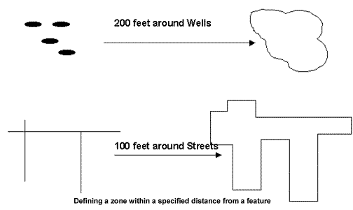
Buffer Operation
Using these operations, the characteristics of an area surrounding in a specified location are evaluated. This kind of analysis is called proximity analysis and is used whenever analysis is required to identify surrounding geographic features. The buffer operation will generate polygon feature types irrespective of geographic features and delineates spatial proximity. For example, what are the effects on urban areas if the road is expanded by a hundred meters to delineate a five-kilometer buffer zone around the national park to protect it from grazing.
Digital Terrain Model
The object of Digital Terrain analysis is to represent a surface and its properties accurately. This is normally achieved by creating a digital terrain model, often known as DTM, formed by sampling the surface. A digital terrain model can be viewed in two different ways:
as an isoline map,
as an isometric model.
Isolines join points of equal value on a surface. The shading defines bands, including all heights, between the isolines.
Isometric models can be shown in three-dimensional models. These models show the terrain in perspective so that the apparent height is proportional to the value of the point. Visualisation techniques are used to project the model from the given eyepoint.