 | Geographic Information Systems as an Integrating Technology |
|
|
|
Geographic Information Systems: A Generic Definition
GIS is a special-purpose digital database in which a common spatial coordinate system is the primary means of reference. Comprehensive GIS require a means of:
Data input, from maps, aerial photos, satellites, surveys, and other sources
Data storage, retrieval, and query
Data transformation, analysis, and modeling, including spatial statistics
Data reporting, such as maps, reports, and plans
Three observations should be made about this definition:
First, GIS are related to other database applications, but with an important difference. All information in a GIS is linked to a spatial reference. Other databases may contain locational information (such as street addresses, or zip codes), but a GIS database uses geo-references as the primary means of storing and accessing information.
Second, GIS integrates technology. Whereas other technologies might be used only to analyze aerial photographs and satellite images, to create statistical models, or to draft maps, these capabilities are all offered together within a comprehensive GIS.
Third, GIS, with its array of functions, should be viewed as a process rather than as merely software or hardware. GIS are for making decisions. The way in which data is entered, stored, and analyzed within a GIS must mirror the way information will be used for a specific research or decision-making task. To see GIS as merely a software or hardware system is to miss the crucial role it can play in a comprehensive decision-making process.
--------------------------------------------------------------------------------
5. Other Definitions
Many people offer definitions of GIS. In the range of definitions presented below, different emphases are placed on various aspects of GIS. Some miss the true power of GIS, its ability to integrate information and to help in making decisions, but all include the essential features of spatial references and data analysis.
A definition quoted in William Huxhold''s Introduction to Urban Geographic Information Systems. (New York: Oxford University Press, 1991), page 27, from some GIS/LIS ''88 proceedings:
". . . The purpose of a traditional GIS is first and foremost spatial analysis. Therefore, capabilities may have limited data capture and cartographic output. Capabilities of analyses typically support decision making for specific projects and/or limited geographic areas. The map data-base characteristics (accuracy, continuity, completeness, etc) are typically appropriate for small-scale map output. Vector and raster data interfaces may be available. However, topology is usually the sole underlying data structure for spatial analyses."
C. Dana Tomlin''s definition, from Geographic Information Systems and Cartographic Modeling (Englewood Cliffs, NJ: Prentice-Hall,1990), page xi:
"A geographic information system is a facility for preparing, presenting, and interpreting facts that pertain to the surface of the earth. This is a broad definition . . . a considerably narrower definition, however, is more often employed. In common parlance, a geographic information system or GIS is a configuration of computer hardware and software specifically designed for the acquisition, maintenance, and use of cartographic data."
From Jeffrey Star and John Estes, in Geographic Information Systems: An Introduction (Englewood Cliffs, NJ: Prentice-Hall, 1990), page 2-3:
"A geographic information system (GIS) is an information system that is designed to work with data referenced by spatial or geographic coordinates. In other words, a GIS is both a database system with specific capabilities for spatially-reference data, as well [as] a set of operations for working with data . . . In a sense, a GIS may be thought of as a higher-order map."
And from Understanding GIS: The ARC/INFO Method (Redlands, CA: Environmental System Research Institute, 1990), page 1.2:
A GIS is "an organized collection of computer hardware, software, geographic data, and personnel designed to efficiently capture, store, update, manipulate, analyze, and display all forms of geographically referenced information."
The use of so many acronyms, synonyms, and terms with related meaning can cause some confusion. Consider a few of the most widely used terms:
AGIS (Automated Geographic Information System)
AM/FM (Automated Mapping and Facilities Management): Automated mapping by itself allows storage and manipulation of map information. AM/FM systems add the ability to link stores of information about the features mapped. However, AM/FM is not used for spatial analysis, and it lacks the topological data structures of GIS.
CAD (Computer-Assisted Drafting): These systems were designed for drafting and design. They handle spatial data as graphics rather than as information. While they can produce high-quality maps, generally they are less able to perform complex spatial analyses.
CAM (Computer-Assisted Mapping, or Manufacturing)
Computerized GIS
Environmental Information System
GIS (Geographic Information System)
Geographically Referenced Information System
Geo-Information System
Image-Based Information System
LIS (Land Information System)
Land Management System
Land Record System
Land Resources Information System
Multipurpose Cadastre:
Multipurpose Geographic Data System
Multipurpose Land Record System
Natural Resources Inventory System
Natural Resources Management Information System
Planning Information System
Resource Information System
Spatial Data Handling System
Spatial Database
Spatial Information System
The GIS View of the World
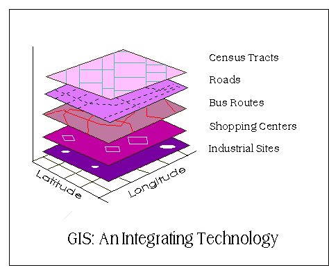
GIS provide powerful tools for addressing geographical and environmental issues. Consider the schematic diagram below. Imagine that the GIS allows us to arrange information about a given region or city as a set of maps with each map displaying information about one characteristic of the region. In the case below, a set of maps that will be helpful for urban transportation planning have been gathered. Each of these separate thematic maps is referred to as a layer, coverage, or level. And each layer has been carefully overlaid on the others so that every location is precisely matched to its corresponding locations on all the other maps. The bottom layer of this diagram is the most important, for it represents the grid of a locational reference system (such as latitude and longitude) to which all the maps have been precisely registered.
Once these maps have been registered carefully within a common locational reference system, information displayed on the different layers can be compared and analyzed in combination. Transit routes can be compared to the location of shopping malls, population density to centers of employment. In addition. single locations or areas can be separated from surrounding locations, as in the diagram below, by simply cutting all the layers of the desired location from the larger map. Whether for one location or the entire region, GIS offers a means of searching for spatial patterns and processes.
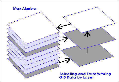
Not all analyses will require using all of the map layers simultaneously. In some cases, a researcher will use information selectively to consider relationships between specific layers. Furthermore, information from two or more layers might be combined and then transformed into a new layer for use in subsequent analyses. This process of combining and transforming information from different layers is sometimes called map "algebra" insofar as it involves adding and subtracting information. If, for example, we wanted to consider the effects of widening a road, we could begin with the road layer, widen a road to its new width to produce a new map, and overlay this new map on layers representing land use.
Geographic Information Systems as an Integrating Technology
How does a GIS work
Data Structures
History of GIS