 | Map Algebra |
The most simple example of interpolation is linear interpolation between two points |
|
Map algebra |
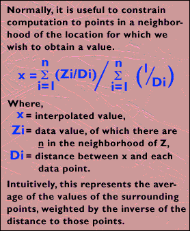
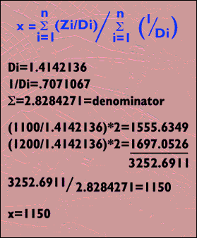
Inverse distance: The following graphic illustrates how to calculate the center point in the second grapic |
|
result |
|
|
Thiessen (Voronoy) Polygons Method. |
Triangulated Irregular Network (TIN). |

Data interpolation. Statistical methods of interpolation.
Map Algebra. Interpolation with raster and vector GIS data
Interpolation is the procedure of predicting unknown values (not measured, etc.) from known (i.e. measured). Usually known measured points are called neighbours. The distances to the neighbours are called search radiuses. Search radiuse distances, relative positions of neighbours, their values and areal extent of the data set constitute necessary elements of the data interpolation model. The relationship between them identify the appropriate method of interpolation, its level of complexity and final results.
In many cases it is necessary to make sure that data contain reliable values and units have proper dimensions. This can be achieved through quality control and quality assurance mechanism.
Many GIS software packages have data interpolation modules, mostly designed to create continuous surfaces. These surfaces represent terrain, bottom of the lake, temperature or distribution of the chemical component.
The procedure opposite to interpolation is called extrapolation. Extrapolation is a procedure of predicting the value of attribute outside of the area covered by measurements, but using some statistical correlation functions as the result of interpolation. This is done most often by creating statistical correlation between two parameters within certain area and using it on a new area or extent. Example: barometric pressure and altitude correlation can be used anywhere in the world, but original correlation has to be done somewhere
Statistical Methods of Interpolation.
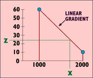
The most simple example of interpolation is linear interpolation between two points
The distance from the point A to the unknown point C is 25 meters ( measured).
2. 20 - 10 = 10 (i.e. difference between values between two points Aand B)
3. 10 units / 50 meters = 0.2 units/meter (i.e. incremental change of values along the distance between two pints)
4. Number of units between point A and point C is 25 meters x 0.2 units/meter = 5 units
5. The answer is: 10 + 5 = 15 units. i.e. the value of unknown point C is 15.
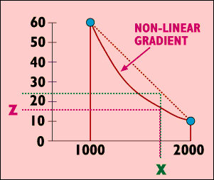
Other methods of interpolation include:
polynomial functions;
splines;
kriging;
moving average;
fourier functions.
Each of them has a specific statistical mathematical mechanism being applied to the data. It is assumed that these mathematical function closely approximate the physical state of data distribution.
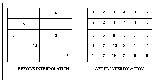
Since the most routine procedure during interpolation is a measurement of distances between data points, it is easier and faster for the computation if data are organized in grids or lattices or matrices.
Grids, matrices and lattices generally maintain equal distances between their elements containing data points and unknown values. For example, grids can have each element (pixel) be equal 10 x 10 meters or 2 x 2 feet. Therefore computational algorithm has these distances as constants and uses only information about pixel numbers to find the search radius or distance. For example, if the pixel size equal 10 x 10 meters, 5 pixels equal 50 meters, etc.
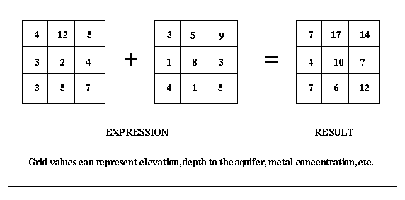
Map algebra is a specific case of GIS data base query and manipulation applied for the raster data. Raster data have only one attribute - integer or floating number, associated with the specific cell (pixel) in the grid.
In exmaple below two grids are added. Each cell has its own unique value and location. The result is a grid with "added" values from corresponding cells.
When expression is being evaluated, cell values are added/subtracted/multiplied. etc., according to the location of each cell in input and output grids. The value of the first cell in the first row can not be added to the value of the second cell in the third row. It can be added ONLY to the cell located in the first place on the first row.
More complex example of the map algebra is a neighborhood analysis that is used for the data interpolation and filtering.
Interpolation with raster and vector GIS data.
Raster Data.
There are many methods in GIS to interpolate raster data., including inverse distance weighted method, spline, trend surface analysis, kriging and artificial neural networks.Two most common raster data techniques are:
Inverse Distance Weighted (IDW) interpolation.
This method assumes that each input point has an influence from the neighbour that diminishes with distance. Therefore, the value of points, located closer to the input point is weighted greater than the value of points located farher.
Spline
This method uses input points as a rigid framework to fit a minimum curvature surface. Input points preserve their location and values. Original idea came from the drafting trade, where splines (drafting tools, consisting of weights and a string) were used to create a smooth surface around selected points.
Vector Data.
In case of vector data there are two most comon methods: Thiessen (Voronoy) Polygons Method and Triangulated Irregular Network (TIN) Method, aka as Delone (original last name of the russian mathematician Delone, Boris Nikolaevich ) and sometimes known as Delauney (his last name was modified later) Method.
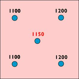
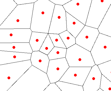
Thiessen (Voronoy) Polygons Method.
The method was developed by the russian mathematician Voronoy, Georgy Fedoseevich (1868 - 1908) and implemented for meteorological studies by the french meteorologist Thiessen in 1911. The method connects input points (in red color) , dissect links in the middle and make a bisecting perpendicular to each link, thus creating a network of polygons around input points (outlined in black color). You have to see the picture, otherwise it is difficult to understand.
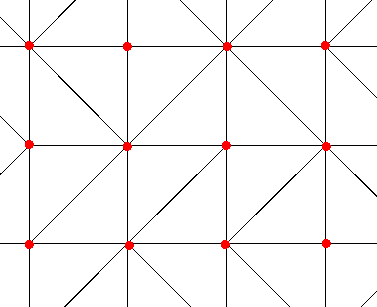
Triangulated Irregular Network (TIN).
The method is the only one way in GIS to display continuous surface using a vector data structure. The input points (red color) are connected with each other and form a network of non-overlapping triangles. This network represents a continuous surface where each triangle has a surface elevation value.
http://www.uiowa.edu/~geog/health/interp/inv.html
Spatial Interpolation
Introduction
Spatial interpolation is used to estimate a value of a variable at an unsampled location from measurements made at other sites.
Strictly speaking, interpolation results are valid within the convex hull described by the sample locations.
Spatial interpolation is based on the notion that points which are close together in space tend to have similar value attributes. This is knows as positive spatial autocorrelation