 | IMPUT and MAP DESIGN |
Database |
Data Base Query and Analysis |
Map Gesign |
Lettering/Labels |
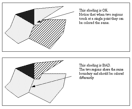
Shading, Colors |
Map Orientation |
Neatline is a box surrounding map elements |
Scale |
|
Data input is the procedure of encoding data into a computer-readable form and writing the data to the GIS data base. There are two types of data to be entered in a GIS - spatial (geographic location of features) and non-spatial (descriptive or numeric information about features).
There are three types of data entry:
Manual (via typing on keyboard or importing text files);
Digitizing;
Scanning;
Manual data entry can bring into GIS either collected or measured data. These data exist as simple text files or binary files. Text files should have at least two columns with X and Y coordinates. These columns allow georeferencing of the file i.e. association of it with specific geographic coordinate system. Binary files are usually a product of the software package associated with measuring device (for example files from Global Positioning System data collection). They also have X and Y data, associated with description of the collected features, but in encoded format that could be read by special software.
Digitizing is a process of entering digital codes of analyzed data into computer. Digitizing can be manual (using digitizing tablet) or automatic (using scanner). The difference between two methods is that digitizing tablet allows to do georeferencing during the digitizing process, while scanning require georeferencing later, after digital file (usually TIFF, GIF or JPEG image) has been created. Another difference between methods is speed and accuracy of the data processing. Apparent slowness of the work on digitizing tablet compensates often for the amount of editing after scanning process. At the same time good scanning allows automatic layer separation (for example, separation of red-colored roads from brown-colored contour lines), while digitizing of the map on a tablet requires manual creation of separate themes. In this case the condition of the original hardcopy is very important. Since human operator can use more cognitive tools and knowledge than the software support for scanning device, digitizer can handle better the hardcopy in a poor condition . Special kind of scanned data is remote sensing image, taken either by satellite camera, digital camera or video camera.
GIS Data Bases and Attribute Tables.
A data base is a collection of information about things and their relationship to each other (Aronoff, 1995).
GIS data base is a collection of connected spatial georeferenced data and non-spatial attribute tables. The connection between them can be based on hierarchical, network, relational or object-oriented models. Relational data bases are still most common models among other types.
SPATIAL GEOREFERENCED DATA - coded information about locations of spatial objects and their relationship (topology). Coding may result in pain text file or compiled file (i.e. by programmming language, such as C or Fortran).
TABLES - general term for the data file organized with:
fields (vertical columns, a.k.a. items).
records (horizontal rows, a.k.a. tupels ).
Attribute tables in GIS are tables connected with spatial georeferenced data via internal links (i.e. provided by the GIS software) or tables in other formats (Dbase files, ASCII files, etc.). GIS software provides means to view all tables, regardless of their source, in a standard visual form.
Relational Data Bases.
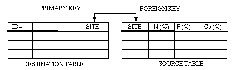
This type is still prevailing model among other models. The principles of relational data bases were first proposed by Dr. E.F. Codd in 1970 in his paper "A relational Model of Data for Large Shared Data Banks". This model consist of collection of objects (two-dimensional tables) or relations. Each table has a field called "primary key" and a key called "foreign key". Primary key field contains unique values (no duplications!). A foreign key refers to a field in another table. It can contain multiple values. It can be also primary key. It must match an existing primary key value or unique key value. In GIS the role of primary key plays unique identifier (i.e. number) of the spatial element (i.e. point, line or polygon). At the same time, different attribute tables might have various keys, depending on the data base purpose and structure. When tables are joined (related) they get connected or at least appear as connected. In this case the table with primary key "adds" to itself a table with foreign key. In some GIS packages (i.e. ARCINFO or ARCVIEW) the table which "relates" another table is also called destination table. The table that "get related" is called "source table".
Frank (1988) outlined the following functionalities of data bases:
1. Allow storage and retrieval of data and data selection based on one or more attributes or relations.
2. Standardize access to data, and separate data storage and retrieval from the use of data in application programs to maintain independence in those programs.
3. Provide an interface between data base and application program based on logical description of the data without requiring details of the physical storage.
4. Make access functions in applications independent of the physical storage structure so that programs are not affected by changes in storage media.
5. Allow several users to access the data simultaneously.
6. Protect the data base from indiscriminate and illegal changes.
7. Provide sound rules for data consistency which will be enforced automatically. These rules are an excellent way of removing errors and inconsistencies from the data base.
There are three types of relations:
One-To-One
Each record in destination table has one match in the source table.
Many-To-One
Many records in the destination table are related to one record in the source table.
In this case each record in destination table will acquire the value (ONLY ONE) of the
"related" record in the source table.
One-To-Many
One record in the destination table is related to many records in the source table.
In this case each record in destination table will acquire the value of the FIRST encountered
"related" record from the source table.
Advantages:
Flexibility
Simplicity
Non-redundancy
Distributed data base management
Disadvantages:
Difficult to implement
Slow performance in some cases
Data Base Query and Analysis.
Data base management system - computer software for organizing and managing the data base. The aim of the data base management system is to make data quickly available to users whilst still maintaining its integrity, to protect the data against deletion and corruption and to facilitate the addition, removal and updating of data as necessary. Usually users request a query i.e. a question about the data in a data base.
In the relational data base there are no restrictions on the range of queries and user does not have to know the structure of the data base.
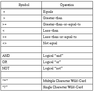
The language that performs such queries is called Standard Query Language (SQL). SQL has statements such as "select", "insert", "update", "delete", "alter", "drop", etc. In GIS software it includes also elements of Boolean logic
MAP DESIGN
Role of the Map in Information Communication.
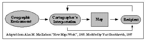
The following diagram shows a schematic depiction of cartography as a process of information communication
Geographic Environment - all available data sources, including GIS data, remote sensing data and spatial natural features which could be measured and used in cartography.
Cartographer''s Interpretation - cartographer''s expertise and education as both cartographer and professional in the topic which the final map deals with. In the process of making a map, the communication between recepient and cartographer is the most important and critical. It doesn''t mean that if Albert Einstein would ask cartographer for a map of electrons circulating around atoms cartographer should meet his background, but cartographer should at least understand what atoms and electrons are as a natural phenomenon and what kind of spatial relation exist between them.
Map - on this diagram the map is not just a communication vehicle, but is one of many potential representations of phenomena in space that a user may draw upon as a source of information.
Recipient - customer who needs a map. From his point of view he knows exactly what he wants, but sometimes he cannot describe it clearly. Therefore an extra loop is needed between the cartographer and recipient to clarify map design/data issues.
Definition of THE BEST MAP: "CLEAR, SIMPLE WITHOUT UNNECESSARY DETAILS AND NECESSITY OF THE VERBAL EXPLANATION".
REMEMBER: A map is not data. MAP IS A VISUAL REPRESENTATION OF DATA.
Data - is what collected in the field, digitized or measured.
Lettering/Labels
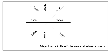
Basic rules for label placement:
1. Users read information from left to the right.
2. Use as many horizontal labels as possible. See the diagram
Specific cases:
Lakes: If large enough to contain entire name, allow the lettering to take a direction in conformance with the general shape of the lake. If too small for this, lakes should be labeled in the same fashion as cities.
Rivers: Letters should follow the river course, or see Major Reed''s diagram above. If stream is wide enough, put its name within the channel; if not, along the bank, preferably above, keeping a clear space of about half the height of the letter between the bank outline and letters.
Basic rules for label text types:
1. STATES, COUNTIES, CITIES;
2. Towns, Villages, etc.
3. LARGE RIVERS, WATERBODIES;
4. Small rivers, waterbodies;
5. Contour line numbers - 15;
Lettering/Label colors can also match color of the symbol to which they refer. For example, if town boundaries are colored red, then town names can have red color also.
Number of colors/shades:
While using colors keep in mind that human eye can distinguish not more than 7-8 colors. Most of the color schemes applied for landuse maps, zoning, etc. look more clear if they have 7 or 8 colors or shades. With more colors it will be difficult to read the map and understand its meaning fast.
Bathymetrical maps or elevation maps have colors, reflecting the range of values. They mainly use one color which changes its intensity with depth or elevation rise/fall.
There is a good practical rule: large areas should be colored/shaded light, while small areas should be colored/shaded with dark or more intensive colores/patterns.
Map Orientation, North Arrow.
There are two reasons why do we need direction aids on a map:
1. To place map correctly in a field and see on terrain where the map features are.
2. To see the relation of geographic features to the coordinate system on a map.
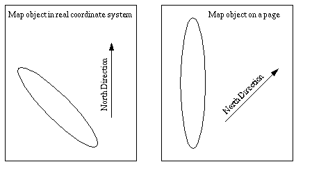
Following is an example when north arrow indicates map orientation.
The general case when cartographer has to rotate map object is when it has to be magnified and fit the page size. It happens only during special projects.
North arrow indicates the location of either magnetic or geographic north. On professional maps there are actually two arrows - one for magnetic and one for geographic pole, but generally people use only one arrow.
The basic rule of cartographic aesthetics states not to overload the map with unnecessary elements. In many cases north arrow is unnecessary element, like for example missed "+" sign before positive numbers. Nobody writes +5 ; usually it goes like 5. In cartography, when projection is rectangular, like State Plane or Mercator, the role of north arrow plays the neatline i.e. surrounding box around all map features. Vertical lines correspond to north-south and horizontal to east-west.
Neatline.
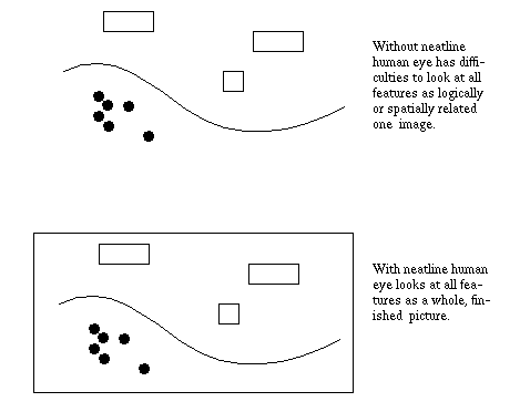
Neatline is a box surrounding map elements. Neatline plays two important roles:
1. Serve as coordinate grid and orientation aid on most maps.
2. Creates visual "grouping" of map element.
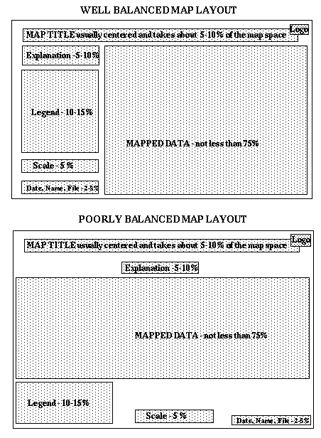
Date, Name, Filename.
Date of the map creation is useful if somebody wants to see the age of data used for the map.
Name helps identify the person who designed the map and deserves credit or
punishment.
Filename can help in identification of the place on computer where map is stored. It is
invaluable tool to return back to the map and either make extra copies or update it. If there
are many different computers in your lab, indicate also the machine name.
Example: 06/07/98, Yuri Gorokhovich, GIS14:/opt/yuri/maps/mymap
Usually this information is placed on a bottom of the map, a little bit above the neatline.
Explanation.
There is also important in some cases to add explanation on the map which would say
something about the purpose of the map or project associated with the map, or specific
things about the data being used for the mapping. Usually this information is placed either under the
map title or above the neatline.
Logo.
Logo usually represents agency''s or company''s symbol. Normally it is placed on the left
or right upper corner of the map.