 | http://www.google.com/search?hl=en&q=crater+mine+death+valley&btnG=Search&aq=f&aqi=&aql=&oq=&gs_rfai= |
Bishop Peak is the highest of nine volcanic coresŚcalled the Morros (the noses) or the Nine SistersŚthat run from San Luis Obispo to Morro Bay in central California. All of them are volcanic necks dating from the early Miocene 20¢25 million years ago. All formed as an abrupt change in the local tectonic regime opened this subduction wedge to rhyodacitic volcanism. The sticky, high-silica rhyolite of the Morros, which once were the deep cores of volcanoes, contrasts vividly with the surrounding serpentinite and melange of the Franciscan formation. |
Rhyolite is a high-silica lava that is chemically the same as granite but is extrusive rather than plutonic - Igneous Rock Types-http://geology.about.com/od/rocks/ig/igrockindex/rocpicrhyolite.htm |
Serpentinite is composed of minerals of the serpentine group. It forms by regional metamorphism of deep-sea rocks from the oceanic mantle - Metamorphic Rock Types- http://geology.about.com/od/rocks/ig/metrockindex/rocpicserpentinite.htm |
Between the red swath signifying the Sierra Nevada granites and the western greenish-yellow band of folded and faulted Coast Ranges lies the great sedimentary trough of the Central Valley. Elsewhere this simplicity is broken: in the north, the blue-and-red Klamath Mountains are torn from the Sierra and moved westward while the dotted pink is where young, widespread lavas of the Cascade Range bury all older rocks. In the south, the crust is fractured on all scales as the continent is being actively reassembled; deep-seated granites marked by red, rising as their cover erodes away, are surrounded by vast aprons of recent sediment in the deserts and rangelands from the Sierra to the Mexican border. Large islands off the southern coast rise from sunken crustal fragments, part of the same vigorous tectonic setting. Volcanoes, many of them recently active, dot California from the northeast corner down the eastern side of the Sierra to its southern end. Earthquakes affect the whole state, but especially in the faulted zone along the coast, and south and east of the Sierra. Mineral resources of every kind occur in California, as well as geological attractions - http://geology.about.com/od/maps/ig/stategeomaps/CAgeomap.htm |
The San Andreas fault is a crack in the Earth''s crust in California, some 1100 kilometers long. Many earthquakes have occurred along it, including famous ones in 1857, 1906 and 1989. It is the boundary between the North American and Pacific lithospheric plates. Geologists divide it into several segments, each with distinct behavior. A research project has drilled a deep hole into the fault to study the rock there and listen for earthquake signals. This page gives information on all these topics.The San Andreas fault is the foremost of a large set of faults along the plate boundary between the Pacific plate on the west and the North American plate on the east. The west side moves north, causing earthquakes as it moves. Over millions of years, it has brought very different sets of rocks to face each other across the fault trace. The forces associated with the fault have pushed up mountains in some places and stretched apart large basins in others. The mountains include the Coast Ranges and the Transverse Ranges, both of which consist of many smaller ranges. The basins include the Coachella Valley, the Carrizo Plain, the San Francisco Bay, the Napa Valley and many others. The California geologic map will show you more about those - http://geology.about.com/od/geology_ca/tp/aboutsaf.htm |
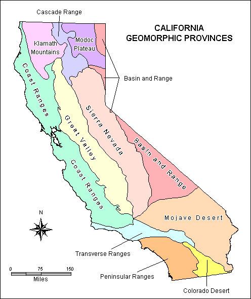
California Geomorphic Provinces are distinctive, generally easy to recognize natural regions in which the geologic record, types of landforms, pattern of landscape features, and climate in all parts are similar. For example, the alpine features of the Sierra Nevada greatly distinguish that geomorphic province from the subdued relief on the valley floor of the Great Valley Province.- http://geology.about.com/gi/o.htm?zi=1/XJ/Ya&zTi=1&sdn=geology&cdn=education&tm=76&gps=92_753_1003_586&f=00&tt=14&bt=1&bts=1&zu=http%3A//www.consrv.ca.gov/cgs/geotour/index.htm |
The upper diagram shows the different parts of the continental-oceanic convergent margin, which I will refer to throughout the tour. Subduction zones are the part where the oceanic plate moves beneath the continental plate, mixing crustal rocks and sediments and fluids into the upper mantle. The lower diagram shows details of that mixing process, sometimes called the subduction factory. It produces high mountains of erupted lava, deep plutonic bodies of granite, and large amounts of sediment that erodes off the mountains. All of those are found in California''s subduction-zone rocks. In addition, parts of the incoming oceanic plate get scraped off by the outer wedge of the continental plate. You''ll see those on this tour, too. California is a famous oceanic-continental convergent margin, and its rocks are considered the type example of the products of this tectonic setting. Northern California displays subduction-zone rocks from the last 500 million years. Today much of coastal California is a transform zone, and sideways motion near the coast has dissected the older rocks. That makes things more complicated, but it also reveals more pieces of the puzzle- http://geology.about.com/od/geophoto_tours/ig/CAtransecttrip/ |
http://www.palomar.edu/geology/DVWeb.htm, http://geology.csupomona.edu/docs/sierra.html, http://en.wikipedia.org/wiki/Great_Basin - geology |
Eurica sand Dunes |
|
Crater Mine, Death valley - http://www.google.com/search?hl=en&q=crater+mine+death+valley&btnG=Search&aq=f&aqi=&aql=&oq=&gs_rfai= |
Basin and radge province |


Bishop Peak
Black Butte
Buck Peak
Burney Mountain
Cave Mountain
Mount Conness
Mount Diablo
Duncan Peak
Glass Mountain
Half Dome
Mount Konocti
Lassen Peak
Lone Pine Peak
Lover''s Leap
Mammoth Mountain
Montgomery Peak
Olancha Peak
Pinto Mountain
Red Hill
Red Mountain
Round Top
Mount St. Helena
Mount St. John
Mount San Antonio
Mount San Jacinto
Santa Ynez Mountains
Mount Shasta
Sutter Buttes
Mount Tamalpais
Telescope Peak
Wilcox Ridge
Mount Wilson
Geologic Map of California (1250x1600)
Online Geology Course
Coastal Geology
Key Trip
Death Valley Geology