 | the Mojave Desert, the Mitchell Caverns,the Rainbow Basin and Death Valley |
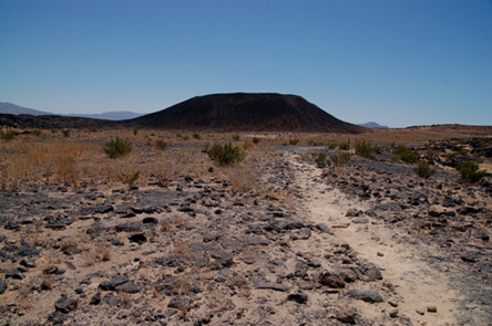
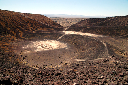
the Amboy Crater.This volcano stands out of a desert landscape formed by basaltic lava flows and Quaternary sediment.While the landscape seems to be very barren, we apparently hiked on "lizard day":big, multi-colored reptiles accompanied us to the base of the crater. |
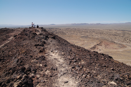
The path along the rim was very narrow, and both sides very steep.A volcano like Amboy Crater is known as a cinder cone, and is composed by pyroclasts.Pyroclasts would form during explosive volcanic activity, when magmas are extremely viscous. |
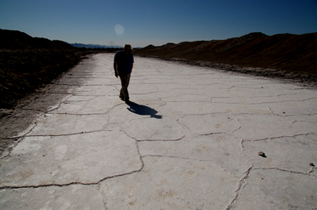
Bristol Lake is actually mined for salt extraction.In this image, we were walking on the salt-hardened surface of a small evaporation channel.Note the white salt polygons, separated by salt ridges, and the mud covering the edge of the salt pan. |
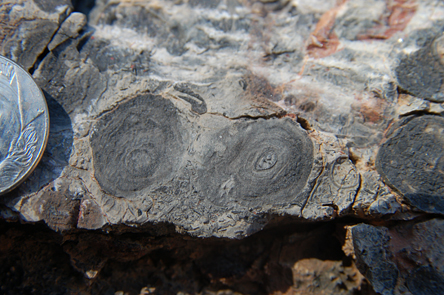
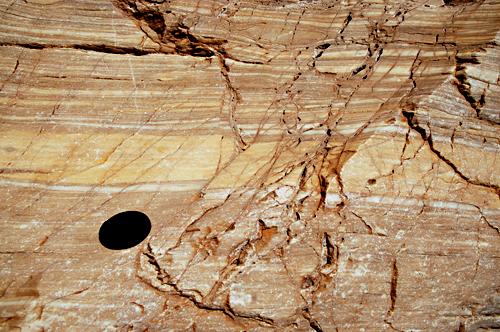
some very old rocks:in the Cadiz Mountains of the Mojave desert, Early Cambrian rocks (as old as 545 million years)represent the ancient edge of the North American continent. Below the Cambrian rocks, the ancient crystalline basement, the remnants of a much older continent (about one billion year old in this area) are found. This image shows some oncolites (coin is for scale).Oncolites are fossil algae that lived in a Paleozoic shallow water ocean,between the edge of the continental shelf and its adjacent slopeAmong these oncolites, which are immersed in a carbonate (limestone) mud,it is not uncommon to find also remnants of trilobites, a characteristic fossil of the Cambrian. |
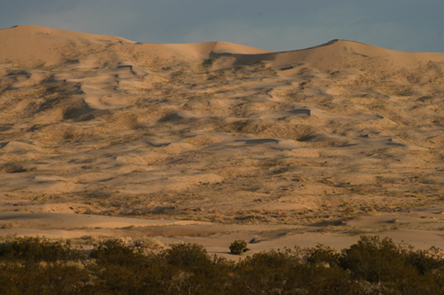
the majestic Kelso Sand Dunes surrounded by creosote bushes, a few desert grasshoppers and butterflies and yes, we were also visited by a snake. |
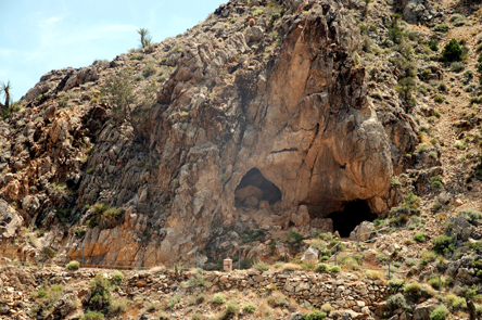
Two eyes was the ancient name of this area in the Providence Mountains - two opening in the easily dissolved limestone give access to the Mitchell Caverns,a medium-sized cave with very characteristic features managed by the State of California.The way into the cavern is a narrow opening into the limestone, but there is more space inside. |
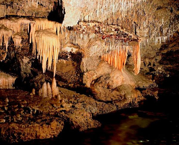
The Mitchell Caverns |
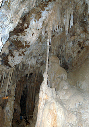
Caves and caverns can form in rocks that can be dissolved by underground water.Most of the times the dissolved rock is a limestone, like in the Mitchell Caverns,but sometimes gypsum caves are found (such as the Lechuguilla Cave in New Mexico) When limestone is dissolved, it moves with the water and then it can deposit again,when water drips from the ceiling or the side of a cave (dripstones and flagstones.Among these, the most known are the stalactites (hanging from the ceiling)and the stalagmites building up from the cave floor).When a stalactite and a stalagmite touch each other, they create a column, which is what we see in this image. |
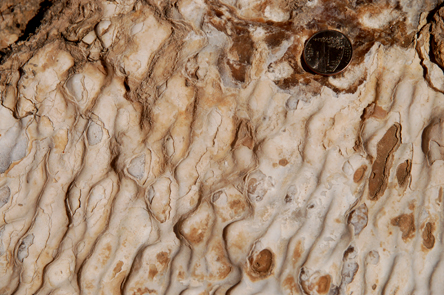
Strange wavy surface, similar to shallow water ripples, are found along the walls of the cave. |
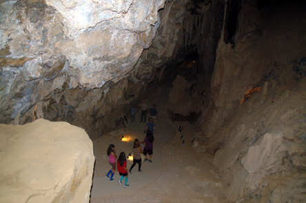
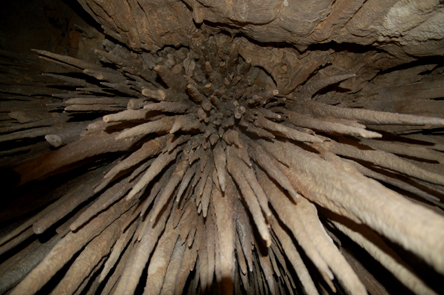
A cluster of stalactites hangs over our group as we move on along the trail. |
through mountains of limestones and boulders of granite |
the Kelso Sand Dunes, a small dune all covered with dark, iron-rich sand. |
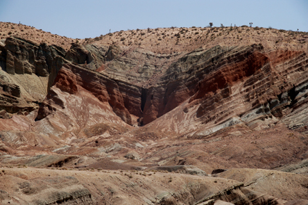
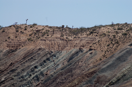
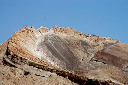
Rainbow Basin, by Barstow- syncline.A syncline is a fold that is arched (or concave) upward: its flanks (limbs) point (dip) towards its center (core).The syncline, with its folded layer, is covered by horizontal layer. This contact is explained (and shown better) in the next image) |
Sedimentary layers usually are part of a sequence of layers.When different sequence cause layers to be at an angle with each other, an angular unconformity develops.Unconformities indicate a gap in time that might occur when rocks between sequences were not deposited or, like in this case, were deposited but then have later been eroded. |
This picture shows a single individual layer, part of the syncline structure,bent and exposed in an exceptional way. Note the people at the top of the layer for scale |
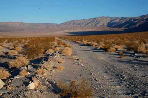
the Panamint Valley |
inside Amboy Crater; two small-sized playa lakes, located at different levels |
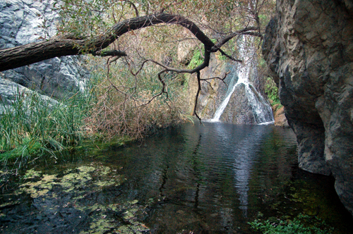
Panamint Springs.Darwin Falls are a splendid oasis in the middle of the desert.The waterfall feeds a little pool at its feet and a small oasis |
The sensation of coolness is increased by the narrow walls of rocks around us and by the formidable colors that carpet the valley floor. |
Mosaic Canyon -a tectonic disturbanceputs horizontal layers (to the left) and vertical layers (to the right) side by side. |
On a smaller scale, some microfaulting visible in these layered marble breaks the original continuity and horizontality of the layers. |
At some locations, the marbles have been deeply eroded by "slurries" (dense flows of water, mud and coarser sediments) that formed after precipitation and that have eventually been cemented in place.Notice the smoothness of the upper surface of the marble,indicating a long and continuous process of abrasion and dissolution. |
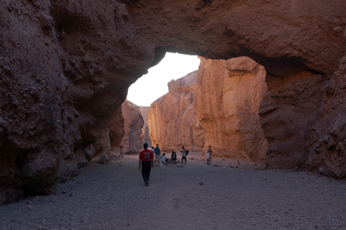
the Natural Bridge |
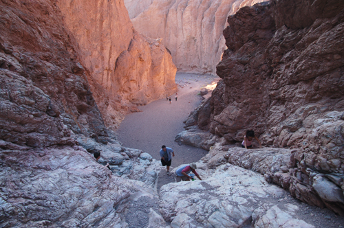
the stream bed |
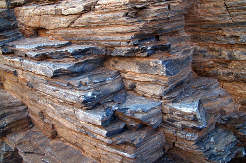
A nice outcrop of shale gave us the opportunity to discuss again how these rocks form and what kind of sedimentary environment they indicate.Fissility of the shale is very visible in this image, where the coin is, again, for scale. |
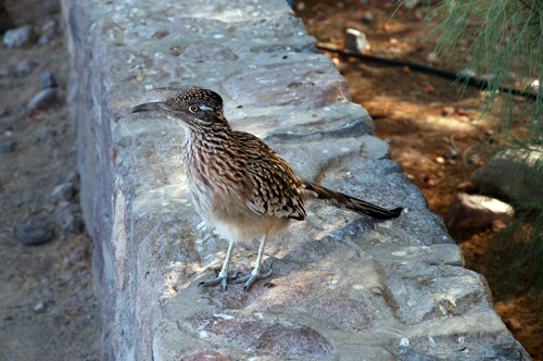
a roadrunner |
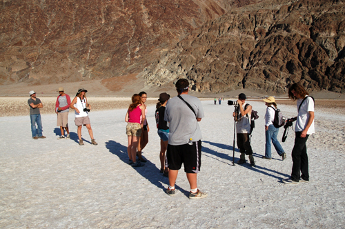
This is Badwater, where the waters flowing through Death Valley collect and eventually evaporate,leaving behind layers of mud and salts of various kinds, mainly halite (table salt) but also gypsum, and borates.The whole group is actually standing on a thick crust of table salt |
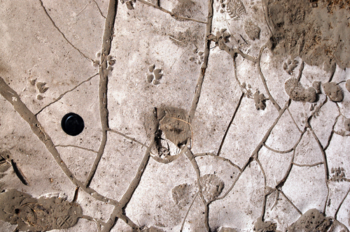
At the bottom of a small desiccated playa, mud cracks testify to the dryness of this environment.A very nice pattern of cross-cutting relationships is evident from this image:the human footprint at center bottom spans across the crack, so whoever walked there did so after the cracks formed.But if you look at the coyote footprint in the middle-upper part of the image you can clearly see that it seems split into two: the crack occurred AFTER the coyote walked there.In order to have such a footprint, the mud must had been fresh, enough to leave behind a sharp track |
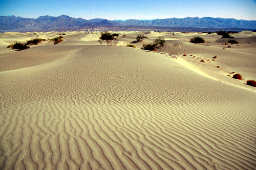
Not far from the Devils'' Cornfield is a field of Sand Dunes.The soft profile of the dunes is here enriched by a pattern of asymmetrical, flat-topped ripplesthat extends all the way to the horizon. The plants are similar to a pillar left behind after strong winds caused deflation in a desert area:these plants hold down soil with their roots while the surrounding areas are blown away when the wind blows. |
|
|
|

This interesting book uses plate tectonics as its central theme; it acquaints readers with California geology. Basic principles in the beginning of the book and tables of highlights for each province enable the reader to understand the whole picture of catastrophic national disasters, California history, mining methods, and societal impacts; it brings the lessons of geology closer to the everyday context of California life. After a comprehensive overview of the basic principles of geology, this book then focuses on the geological highlights of California (young volcanoes, deserts, the Mojave Desert, the Sierra Nevada, the Klamath Mountains, water, the Great Valley, the coast Ranges, earthquakes, faults, and seismic safety, the transverse ranges, and the peninsular ranges). The inside back and front covers of the book contain a wealth of readily available information, with comprehensive geologic, fault, relief, and mountain range maps. A handy desk reference for geologists, this book is also a source of information for anyone interested in the evolution of California''s terrain.
From the Publisher
With California plate tectonics as a central theme, this text is intended to acquaint non-geologists with California geology. Organized to introduce basic principles in the beginning of the text and work toward a unifying picture of California geology. --This text refers to an out of print or unavailable edition of this title.
From the Back Cover
Organized to introduce basic principles and work toward a unifying picture of California geology. With California plate tectonics as a central theme, this book is intended to acquaint non- geologists with California geology. Contains examples of catastrophic natural disasters, excerpts from California history, illustrations of mining methods, and discussions of the societal impacts of geologic processes. A book for practicing geologists in California or any region where fault lines are present and plate tectonics affect the immediate geography. --This text refers to an out of print or unavailable edition of this title.
About the Author
Deborah R. Harden is a Professor in the Department of Geology at San Jose State University, where she teaches undergraduate and graduate courses in California geology and Earth-surface processes. Her particular interests are in landscape-forming processes, rivers, the effects of faults on streams, human impacts on watersheds, and California geology.
Before coming to San Jose State University, Dr. Harden worked as a geologist for a private engineering consulting firm and as a hydrologist for the U.S. Geological Survey. She has a Ph.D. from the University of Colorado and B.S. and M.S. degrees from Stanford University, all in geology.
Dr. Harden has had the privilege and opportunity of visiting and studying geology and landscapes in many parts of the world, both professionally and with her family.
Excerpt. ® Reprinted by permission. All rights reserved.
Almost 100 years ago, on April 18, 1906, Californians encountered one of the unwelcome consequences of living on an active tectonic plate boundary, when the 1906 earthquake destroyed many of northern California''s communities. As we approach the centennial of the earthquake, we can appreciate our increased understanding of California geology and the greater preparedness for natural disaster that has come with that knowledge. Most Californians are aware that earthquakes, volcanic eruptions, floods, and landslides have geological causes, but they are less aware of the positive influences of plate tectonics on the state''s history, economy, and quality of life. Resources such as gold, petroleum, and fertile soils are products of California''s geologic history, as is the diverse and beautiful landscape of our state. The supply, distribution, and safety of water in California will continue to be a major force in the state''s future, and they are partly controlled by geology.
These are some of the reasons that students are attracted to beginning geology courses. Many of these students are not particularly interested in detailed information about rocks, formations, geologic models, or ages of materials. Many come to these courses without prior background in geology and without fluency in the complex vocabulary of geology and science in general. This book is intended to acquaint those students with the basic geologic history of California and to cover those topics that do interest non-geologists. I have included examples of natural disasters, aspects of California history that are tied to geology, geological resources, and discussions of the impact of geology on California society. These topics bring the relevance of geology to the daily context of California life.
PURPOSE
This book is intended for a semester-long course in California geology, but covering all of the chapters in detail during that time is not a realistic goal. Instructors are encouraged to cover the introductory and final chapters and to select the chapters from Part II that focus on their own location and interest. A college student, pre-college teacher, or interested citizen should be able to comprehend the material without having had a prerequisite course in geology. However, the content is also informative to geology majors, graduate students, and practicing geologists not intimately acquainted with California geology.
Readers who complete this book should have a solid understanding of the following major concepts:
Geology is a logical, non-intimidating, and enjoyable science.
Geologists study geologic processes to better understand California''s geologic history as it is preserved by rocks, sediments, and structures.
Maps and cross sections are a fundamental tool of geology.
Plate tectonics has been the dominant factor that shapes California''s geology and landscape.
California''s natural resources and hazardous natural events result from our geologic and tectonic setting.
Geologists work with government agencies to mitigate the impact of earthquakes, volcanic eruptions, floods, and landslides on California citizens, and to inform us about risks.
California has many beautiful natural landscapes and geologic wonders that we can enjoy at hundreds of parks and preserves throughout the state.
ORGANIZATION
California Geology is divided into three sections. The first four chapters are intended to introduce readers to the basic principles of geology. Because the basic concepts are illustrated with California examples, those with previous geology background will also benefit from the material in Part I.
Part II, Chapters 5 through 17, covers the major features of California''s provinces and important geologic processes that are not specific to a single province. For each province, I have selected the most important geologic features or events. Therefore, these chapters do not cover all rock types, events, or geologic features found in each part of California. These chapters begin with less geologically complex areas, and later chapters assume that the reader has acquired the fundamental knowledge given in earlier chapters. However, it is possible to cover these chapters in a variety of orders and to eliminate some entirely during a semester, as I do during my own course. For courses with emphasis on southern California, I would advise beginning with the desert provinces and the Sierra Nevada before moving to the Transverse or Peninsular ranges chapters.
In my opinion, it is important to cover the final two chapters (Part III) during any course on California geology because they unify the material presented in earlier chapters. A synthesis of the geologic development of California through time, presented in Chapter 18, is a good way to review the material in Part II. The final chapter of the book reviews the geologic processes that created hazards for California citizens, the geologic causes of those hazards, and the measures taken to mitigate and prepare for hazardous events. This is perhaps the most important "take-home lesson" for non-geologists who plan to live and work in California.
NEW FOR THE SECOND EDITION
Chapter Summaries: A list of major points or events appears at the end of each chapter. For chapters covering California''s geomorphic provinces, major geologic events are listed in chronological order.
Province Highlights: Major geographic features, dominant rock types and tectonic setting, recent earthquakes, and major parks are summarized in a table at the beginning of chapters covering California''s geomorphic provinces. Simplified index maps and an improved map of the geomorphic provinces allow students to better locate themselves within the state.
Web and Media Resources: An updated list of Web sites and videos is included in the reference section at the end of each chapter.
Highlights of National Parks: Chapters covering California''s geomorphic provinces also highlight the geologic setting and major features of California''s 12 national parks and monuments, as well as selected state parks.
Updated Maps and Diagrams: Newly available maps and diagrams, many from the U.S. Geological Survey and the California Geological Survey, help to clarify basic principles and California''s geologic history.
More Coverage of Southern California Geology: Updates are included on tectonics, basement geology of southern California, and late Cenozoic tectonic rotation.
Paleogeographic Maps: Generalized maps, provided by Dr. Ron Blakey of Northern Arizona University, show the tectonic development of California in geologic time. These maps appear in Chapter 18.
New Topics: Additional topics covered in this edition include: Owens Lake and its impact on the environment, caves of the Sierra Nevada Province, Lake Tahoe, water supply controversies in southern California, groundwater contamination by perchlorate, vernal pools, tsunami hazards along the California coast, the Hector Mine earthquake, and the St. Francis dam disaster.
Slide Set: Also available with the new edition is a slide set of 50 slides from locations throughout California, which illustrate various geologic processes discussed in the book. Contact your local Prentice Hall representative to obtain a set.
HISTORICAL GEOLOGY
Lecture Textbook: S. M. Stanley, Earth System History, 3rd edition (2009), W. H. Freeman and Company, New York
Lecture Textbook: J. W. Schopf, Cradle of Life, 1st edition (1999), Princeton University Press, Princeton and Oxford
Lab Manual:H. L. Levin and M. S. Smith, Laboratory Studies in Earth History, 9th edition
Table of Contents
Pt. I Basic Principles of Geology
1 Plate Tectonics and California 3
2 California''s Rocks 15
3 Geologic Time, Dating Earth Materials, and California Fossils 33
4 Geologic Maps and Sources of Information 47
Pt. II Geologic Highlights of California
5 Young Volcanoes: The Cascades, the Modoc Plateau, and the Long Valley Caldera 55
6 California''s Deserts: Climate, Changing Environments, and Resources 90
7 The Basin and Range and Majove Desert: Old Rocks and Young Faults 113
8 The Sierra Nevada: Granite, Gold, and Glaciers 141
9 The Klamath Mountains: Accreted Terranes and a View of the Mantle 194
10 Water in California 205
11 The Great Valley: Sediments and Soils 233
12 The Coast Ranges: Mountains of Complexity 252
13 Earthquakes, Faults, and Seismic Safety 289
14 The San Andreas Fault System 317
15 The California Coast 362
16 The Transverse Ranges, the Los Angeles Basin, and the Offshore Islands: Compression and Rapid Change 381
17 The Peninsular Ranges 414
Pt. III California Geology: An Integrated View
18 The Evolution of California Through Geologic Time 427
19 Geology and California Citizens 439
Glossary 453
Place Index 462
Subject Index
Synopsis
This interesting book uses plate tectonics as its central theme; it acquaints readers with California geology. Basic principles in the beginning of the book and tables of highlights for each province enable the reader to understand the whole picture of catastrophic national disasters, California history, mining methods, and societal impacts; it brings the lessons of geology closer to the everyday context of California life.
After a comprehensive overview of the basic principles of geology, this book then focuses on the geological highlights of California (young volcanoes, deserts, the Mojave Desert, the Sierra Nevada, the Klamath Mountains, water, the Great Valley, the coast Ranges, earthquakes, faults, and seismic safety, the transverse ranges, and the peninsular ranges). The inside back and front covers of the book contain a wealth of readily available information, with comprehensive geologic, fault, relief, and mountain range maps.
A handy desk reference for geologists, this book is also a source of information for anyone interested in the evolution of California''s terrain.
ĢText can stand alone as a useful tool for non-geologists and geology students covering basic principles of geology without previous geological experience.
ĢExamples of catastrophic natural disasters, excerpts from California history, illustrations of mining methods, and discussions of the societal impacts of geologic processes bring the lessons of geology closer to the everyday context of California life.
ĢOrganization:
◦Chapters 1-4 provides an overview of physical geology as it relates to California.
◦Chapters 5-8 introduces major features of specific provinces or important regional process (because some features and processes cross over province boundaries).
◦Chapters 19 and 20 assemble a unifying picture of the state''s geology.
CHAPTER I. BASIC PRINCIPLES OF GEOLOGY
Plate Tectonics and California. California''s Rocks. Geologic Time, Dating Earth Materials, and California Fossils. Geologic Maps and Sources of Information. CHAPTER II. GEOLOGICAL HIGHLIGHTS OF CALIFORNIA
Young Volcanoes: The Cascades, the Modoc Plateau, and the Long Valley Caldera. California''s Deserts: Climate, Changing Environments, and Resources. The Basin and Range and Mojave Desert: Old Rocks and Young Faults. The Sierra Nevada: Granite, Gold, and Glaciers. The Klamath Mountains: Accreted Terranes and a View of the Mantle. Water in California. The Great Valley: Sediments and Soils. The Coast Ranges: Mountains of Complexity. Earthquakes, Faults, and Seismic Safety. The San Andreas Fault System. The California Coast. The Transverse Ranges, The Los Angeles Basin, and the Offshore Islands: Compression and Rapid Change. The Peninsular Ranges. CHAPTER III. CALIFORNIA GEOLOGY: AN INTEGRATED VIEW
The Evolution of California Through Geologic Time. Geology and California Citizens. Glossary.
Place Index.
Subject Index.
Plates: Inside Front and Back Covers
Plate 1. Geologic Map of California.
Plate 2. Fault Map of
California Geologic History
California Geologic History
California Resources
Tour of Geologic Time
California Geology